Roquefort-sur-Soulzon
You can help expand this article with text translated from the corresponding article in French. (December 2008) Click [show] for important translation instructions.
|
Roquefort-sur-Soulzon | |
|---|---|
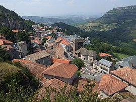
 A general view of Roquefort-sur-Soulzon | |
| Coordinates: 43°58′39″N 2°59′23″E / 43.9775°N 2.9897°E | |
| Country | France |
| Region | Occitania |
| Department | Aveyron |
| Arrondissement | Millau |
| Canton | Saint-Affrique |
| Government | |
| • Mayor (2020–2026) | Bernard Sirgue[1] |
Area 1 | 17.03 km2 (6.58 sq mi) |
| Population (2022)[2] | 502 |
| • Density | 29/km2 (76/sq mi) |
| Time zone | UTC+01:00 (CET) |
| • Summer (DST) | UTC+02:00 (CEST) |
| INSEE/Postal code | 12203 /12250 |
| Elevation | 424–828 m (1,391–2,717 ft) |
| 1 French Land Register data, which excludes lakes, ponds, glaciers > 1 km2 (0.386 sq mi or 247 acres) and river estuaries. | |
Roquefort-sur-Soulzon (French pronunciation: [ʁɔkfɔʁ syʁ sulzɔ̃]; Occitan: Ròcafòrt, [rɔkaˈfɔɾt]) is a commune in the Aveyron department, in the region of Occitania, southern France.
Roquefort is located on the Causse du Larzac and is famous for its ewe derived products including milk, wool and meat. Much of the activity in the commune centres on the production and distribution of Roquefort cheese. To be legally termed Roquefort cheese, it must follow the rules laid down by the federal standards of the Appellation d’Origine. According to archaeologists, the cheese making process in the specific caves dates back to 900 C.E.[3]
A visitor centre illustrates the process of making Roquefort cheese and offers guests a chance to sample and purchase the product. Visitors can also visit the Cambalou caves which are 2 kilometres (1.2 mi) long and 300 metres (980 ft) wide in which the cheeses are aged before they are ready to be sold.
Demographics
[edit]| Year | Pop. | ±% |
|---|---|---|
| 1962 | 1,488 | — |
| 1968 | 1,349 | −9.3% |
| 1975 | 949 | −29.7% |
| 1982 | 880 | −7.3% |
| 1990 | 789 | −10.3% |
| 1999 | 679 | −13.9% |
| 2008 | 685 | +0.9% |
See also
[edit]References
[edit]- ^ "Répertoire national des élus: les maires". data.gouv.fr, Plateforme ouverte des données publiques françaises (in French). 2 December 2020.
- ^ "Populations de référence 2022" (in French). The National Institute of Statistics and Economic Studies. 19 December 2024.
- ^ "Société des Caves de Roquefort". Atlas Obscura.
External links
[edit]


